The slow fracturing of Africa in Ethiopia
The Afar Rift is the only place on Earth where a continent is about to open up to the sea. A researcher at the University of Bern is modelling the activity in this region, which combines seismic risk and geothermal potential.
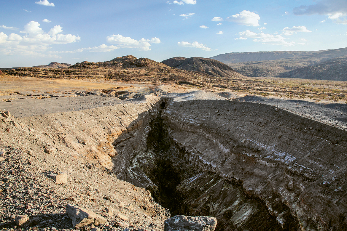
This large crevice in the ground occurred when the Dabbahu volcano erupted in the Afar Triangle in 2005. It’s now called the Dabbahu Rift. Image: Rupert Smith
A rift is forming in the Earth’s crust. It grows over millions of years, sometimes tearing apart entire continents and opening up to the oceans. This is how rifts, major geological phenomena, work. They separated the Americas from Europe and Africa. They continue to widen the Atlantic. By fracturing the seabed, they have allowed the magma from the depths to rise and have given rise to new territories, such as Iceland and the Azores.
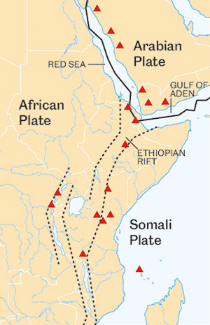
Today, the most active rift system on our planet is in East Africa. At the Afar’s junction, the Gulf of Aden, the Red Sea and the Ethiopian Rift meet. “This area is unique in the world”, says Frank Zwaan, a postdoctoral researcher at the University of Bern. “It brings together all the sequences of events, from faults in the Earth’s crust to volcanic zones to the formation of an ocean. Nowhere else can the evolution of rifts be studied like in this region”.
The Gulf of Aden and the Red Sea are the oldest parts of the junction. They began to form 30 million years ago, when the Arabian Peninsula broke away from the African continent. The most recent is the Ethiopian Rift and its dizzying cliffs, whose creation is believed to have begun about 10 million years ago. Between these three formations lies the Afar Rift. The region is volcanic – the stretching of the earth’s crust has led to cracks through which magma rises. It is home to black basalt plains, heated by the sun to over 60 degrees, lava lakes, hot and acidic springs and the lowest point in Africa: 155 metres below sea level.
Zwaan’s work aims to better understand the evolution of the rift and, in particular, the direction in which the rock masses are moving. It should also contribute to seismic risk management and the exploitation of geothermal potential in the region.
Sightings on Google Earth
Before his trip to Ethiopia, the geologist started with a preliminary exploration on Google Earth. “It gave me a good idea of the location of the most interesting and accessible structures”, he says. This approach proved useful in planning the trip. In this rugged region, accessibility is not always easy, nor is obtaining work permits.
In twelve days and more than 700 kilometres of driving, the geologist and his Ethiopian and Italian colleagues visited many points of interest identified from their computers. Zwaan noted the vertical scrapes that mark the massive boulders as they rub against each other when they move. These scratches are of great importance: the boulders shift too slowly to be observed moving, but using the scratches makes it possible to deduce the direction of their movement. “The more data points we have in the region, the better we understand where and how the continents are moving”, says Zwaan. To estimate the rift dynamics even more precisely, he also used data from local earthquakes.
Zwaan is now working on analog models of the Afar. At the University of Bern, he builds these structures with sand and silicone – the former imitates surface movements, the latter the fluidity of the deep layers. An engine plays the role of tectonic forces, spreads the model apart and generates faults and terraced configurations, just as in the field. According to Zwaan, this approach has many advantages over computer models. “With a computer, it only takes a tiny error in an equation to skew the results completely. With a physical model, you don’t need formulas for gravity or fluid mechanics. Nature takes care of that for you”.
Resources and risks
The stakes of this work are not limited to scientific curiosity. The Afar’s volcanism lends itself particularly well to geothermal exploitation”, says the geologist Ameha Atnafu Muluneh. He is a researcher at Addis Ababa University and took part in the field surveys with Zwaan. “Our studies can be used to estimate the region’s resources. We need to understand better where the structures that serve as conduits for geothermal fluids can be found”, he says. Today, two geothermal power plants are already producing electricity in Ethiopia – one in the Ethiopian Rift Valley, the other in the Afar. Local geologists are considering the exploitation of additional sites, adds Muluneh.
Another potential application – albeit less sustainable – is oil exploration. “It takes very specific conditions for oil to form in a rift. By reconstructing the sequence of events, step by step, we can estimate the location of the deposits more precisely”, says Zwaan.
Finally, this work could contribute to risk management. Like all active rifts, the Afar is a seismic region. With more detailed information on the movement of landmasses, we can better identify risk areas, determine the position of monitoring tools and improve forecasting models.
Dèzes notes the unspectacular character of the Rhine Graben. “There is, however, debate about its possible role in the famous Basel earthquake of 1356. But today, even if there is a little more seismic activity around the moat, it’s frankly not huge”.
Nor should the future hold any surprises, as the Rhine Graben is not expected to see any significant increase in activity. There is no risk, therefore, that it will tear northern Europe in two and open up a new ocean. “According to most experts, this is unlikely to happen, at least not in the next ten million years”.