Never-ending mud
What triggered the eruption of the Earth’s biggest mud volcano on the Indonesian island of Java? An international team of researchers has found the answer.
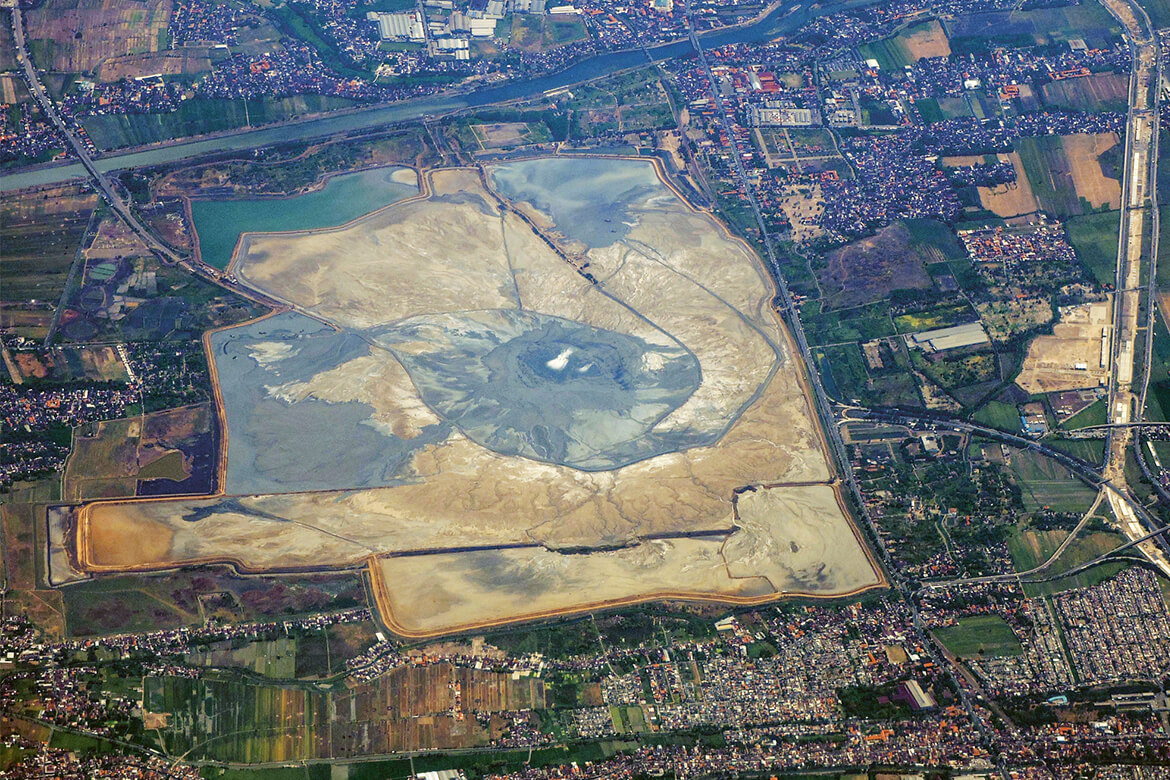
The mud lake of Sidoarjo in Indonesia originated in the world’s biggest mud volcano. Since 2006, it has driven 60,000 people from their land. | Image: Getty Images/Mangiwau
For 13 years now, mud has been shooting out of the Earth in eastern Java in Indonesia. It has killed 13 people and driven 60,000 from their homes in the province of Sidoarjo – and no one knows how long this brown flood will continue. It’s the biggest eruption of mud in the world. For a long time it was unclear just what has been driving it, but an international consortium of researchers has now solved the riddle. The team in question includes Stephen Miller, a professor of geothermics and geodynamics at the University of Neuchâtel, and Matteo Lupi, an assistant professor of geophysics at the University of Geneva.
Was it the drilling or the quake?
Right from the start, the mud eruption was linked by people to two events. On 27 May 2006 there was an earthquake in Yogyakarta, 250 kilometres from Sidoarjo, measuring 6.3 on the Richter scale. It killed over 5,000 people when their homes collapsed. One day later, a drilling operation for crude oil in Sidoarjo went wrong. At a depth of 2,800 metres, an unidentified liquid streamed into the borehole, the drill bit could not be retrieved, and the borehole was sealed up. While the eyes of the world were on the catastrophe caused by the earthquake, cracks in the ground appeared for several hundred metres around the borehole in Sidoarjo, and mud began to bubble out of the earth in five different places. Shortly afterwards, fountains of mud short out of the earth like geysers, and there were plumes of smoke reaching several hundred metres into the skies. Many people in the region suspected that the failed drilling mission had triggered the mud eruption, and a few scientists were of the same opinion. It wasn’t long before researchers from four different continents arrived to investigate ‘Lusi’, as the eruption was soon being called – combining the first syllables of the words ‘Lumpur (‘mud’ in Indonesian) and ‘Sidoarjo’, the name of the province.
According to Miller, who is researching in the international ‘Lusi Lab’ project, there is nothing to suggest that the mud volcano was set off by drilling for oil. “What we’re seeing in eastern Java is a tectonic event, and drilling a foot-wide hole can’t cause that”, he says. And the proof against the drilling hypothesis is clear. The mud discharge contained fossils coming from layers of rock 1,000 metres deeper in the Earth than the deepest point of the failed drilling operation. There’s also another matter to consider: “If the drill had entered a layer that was under great pressure, then the mud would have erupted out of the borehole”, says Miller. “Instead, the first eruptions occurred 700 metres from the hole, and no mud came out of the hole itself”. The Lusi Lab project was also able to collect comprehensive evidence that it was the Yogyakarta earthquake that had triggered the mud eruption. Using computer simulations, Miller and Lupi were able to demonstrate that the layers of rock in the Earth had captured the vibrations of the quake like a parabolic reflector, intensifying them and transporting them to the layer that has since been spewing out mud to this day.
Like a pressure cooker
The research consortium also sent out drones to analyse the gases present in the pillars of smoke. These contained mostly carbon dioxide and freshly created hydrocarbons that are only formed at temperatures over 400 degrees Celsius. “You don’t find these temperatures in the ground in this region”, says Miller. “So there has to be a source of heat inside Lusi”. The following scenario is the most plausible: For years, water must have been held trapped some 1,500 metres below the surface of the Earth. It was under high pressure, and hot magma began to approach it from the highly active volcanoes we find in this region. “The heat released gases in the rock and also enabled water to vaporise in the layers of clay further towards the surface”, says Miller. “All this meant that the pressure continued to intensify – and then came the earthquake that ripped off what was effectively a sealing cap made of hard rock above it all”. Since then, water, liquid clay and rock have been hurled upwards.
It’s impossible to offer a prognosis for how long this mud will keep spewing out of the Earth. But scientists can still learn a lot from Lusi. “We have been observing the birth and development of a hydrothermal system linked to a volcano, and you only get a chance like this once in a million years”, says Miller. “It’s as if we were able to observe tectonics in real-time”. He is here able to investigate a process that is still only barely understood: the impact earthquakes can have over great distances.
The inhabitants of the region have meanwhile come to terms with Lusi. The mud is held back by dams ten metres high, and every day a column of lorries takes away enough of it to prevent the basin from spilling over. The little town that once stood here will never be inhabitable again, however; today, it lies 200 metres below the surface of the mud.