The power of the emerging Earth
Volcanic eruptions are a surface expression of events in the Earth’s crust. Researchers have been photographing these ever-changing landscapes to try and understand subterranean dynamics.
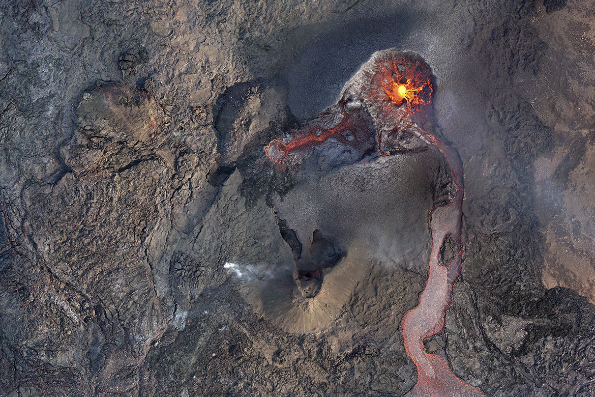
This so-called orthomosaic is comprised of 40 photos taken by a drone on 5 May 2021, in between the fountains of lava regularly spat out by the craters. | Image: Elisabetta Panza
The Earth is renewing itself here with red-hot magma, surging up from 20 kilometres below the surface. In February 2021, during the magma’s long journey up, it sparked multiple on the Reykjanes peninsula of Iceland. In response, Elisabetta Panza and her colleagues from the Volcano Tectonic Laboratory at the University of Geneva travelled to the site hoping to witness the eruptions they believed were imminent. “This was kind of an event. I normally map older parts of land in areas that are still tectonically active. They can also potentially erupt, but here it happened directly in front of our eyes”.
The spectacle began on 19 March. And the researchers weren’t the only people who had come to see it. There were also plenty of tourists. “It was an effusive eruption, which means that the lava flows slowly and steadily from the craters. That meant people could go very close up to it”, says Panza. Sightseers were even aboard airplanes and helicopters flying right over the emerging magma. But on the early morning of 5 May, a ‘no-fly time’ was declared for the researchers to work undisturbed. One of the results of that morning is a so-called orthomosaic – that’s the image shown here, which is a composite made of numerous drone photos.
“I was piloting the drone while my professor and another researcher were observing it,” says Panza. “The eruption had made a completely new topography. That meant we couldn’t rely on existing maps and instead needed to use our own eyes to check whether the drone was covering the whole area”. Their team had to coordinate a lot of activities: keeping the batteries warm under their clothes, staying away from the wind while taking off and landing, watching out for trespassing airplanes, and always flying and landing the drone between the fountains of lava that the craters spat out roughly every five minutes. But the researchers got what they wanted: accurate pictures of the structure of the lava field. “The vents are generally the surface expression of the structure of the crust. The orthomosaic gives us an idea of the dynamics of the fractures underneath”, says Panza.
The landscape changes every day during eruptions, which means that the eruption seen here on the picture has long disappeared, as have the two craters. “It is a very imposing image”, says Panza. “It really shows the power of the Earth: it’s something that we can’t control, but only watch”.